Platinum Way Cycleway Improvements - Stubble Hill
Overview

Buckinghamshire Highways are proposing to implement Double Yellow Lines (DYLs) at the junction between Stubble Hill, Mill Meadow, and Long Leys as part of the Platinum Way (formerly Emerald Way) Cycleway Improvements. The proposed restrictions are aimed to do the following:
- Enhanced Visibility: The parking restriction will improve visibility for those crossing the junction, and allowing cyclists and drivers to see each other more easily, as any vehicles would be discouraged from parking within this junction area.
- Safer Crossing: Pedestrians and cyclists will be better seen by drivers, reducing the risk of accidents.
The Platinum Way Cycleway Improvements is designed to be part of a broader initiative to enhance the Platinum Way Active Travel route between Aylesbury Town Centre and Aylesbury Vale Parkway station. The Platinum Way (formerly known as Emerald Way) spans 3 miles, connecting local schools, businesses, and community facilities. It encourages walking and cycling, contributes to better air quality, and helps alleviate congestion.
Further Information
For more information about the Platinum Way, please click on this link - Platinum Way cycle route | Buckinghamshire Council.
We would like to hear your thoughts on the proposals.
What We Are Proposing
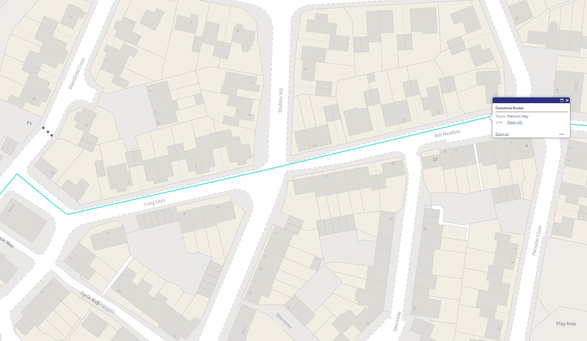
We are proposing to implement parking restrictions in the form of Double Yellow Lines at the junction between Stubble Hill, Long Leys, and Mill Meadow. This junction is located within Fairford Leys in Aylesbury. The Figure below shows the location of the aforementioned roads in relation to the Platinum Way Cycleway (highlighted in a blue line).

The proposed restriction is listed in the table below:
| Road Name | Proposed Parking Restrictions |
|---|---|
| Stubble Hill / Long Leys / Mill Meadow | 'No Waiting at Any Time' (Double Yellow Lines) - To be effective 24 hours a day / 7 days a week. |
Related Documents
You can view the plans and related documents by clicking on the links below:
- Stubble Hill Double Yellow Lines - Draft Order Map Plan (DV46) - 756KB, PDF (Our proposals are shown with a red text. Blue texts denote an existing restriction - which we are not amending).
- Detailed Location Plan of Proposals - 563KB, PDF
- Public (Site) Notice - 108.6KB, PDF
- Statement of Reasons - 139KB, PDF
- Letter to Residents - 285.2KB, PDF
- Draft Traffic Regulation Order - 61.7KB, PDF
How to have your say
You can comment on the proposal in one of the following ways:
- Complete the online survey using the link at the end of this page.
- Email us at: parkingTRO@buckinghamshire.gov.uk
- Write to us at Design Services, Buckinghamshire Highways, Floor 10, Buckinghamshire Council Walton Street Offices, Walton Street, Aylesbury, HP20 1UA.
If you have any questions about this consultation, please email us at parkingTRO@buckinghamshire.gov.uk.
Please tell us about your views by 11:59pm on Thursday 30th May 2024.
What happens next
We will consider all the responses and prepare a report. The Council Leader will review the report and make a decision about the proposed scheme.
The results of the consultation and the Council’s decision will be published on this webpage. Consultees will be informed of the decision once it has been made, via the website.
Privacy
We will use the information you provide here only for this activity. We will store the information securely in line with data protection laws and will not share or publish any personal details. For more information about data and privacy, please see our Privacy Policy.
If you have questions about data and privacy, please email us on dataprotection@buckinghamshire.gov.uk. Or you can write to our Data Protection Officer at Buckinghamshire Council, The Gateway Gatehouse Road, Aylesbury, HP19 8FF.
Areas
- Aylesbury
Interests
- Transport
- Sport & Leisure
- Roads & parking

Share
Share on Twitter Share on Facebook